
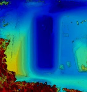
Marshall Junior High School elevation map created by Juays Photography Aerial Services.
© Juays Photography Aerial Services
New Marshall Junior High School is going to flood!
Table of Contents
Just wait till we get our 1st rain, that new junior high school is going to flood. How many times have you heard that or maybe even thought that? Not according to an elevation map created by Juays Photography Aerial Services.
Now I am no construction expert, but I do know that water will always run to the lowest point. I also know that before the construction of any structures started many drains with piping/culverts (excuse my non-technical terms) were laid to move water away from the school grounds towards the “French drain”. Now where I come from a French drain is what you know as a septic system. However, I have since learnt that a French drain redirects water from a given area. The architects of the new Marshall Junior High have incorporated a French drain to ensure that the grounds are not flooded and kept reasonably dry. According to the project update for November the French drain is only 65% complete.
I did an aerial visit of the site after we had received 4″ of rain and the site looks reasonably good. There is no pooling of water, apart from it being very muddy, which is what you would expect from a construction site after some heavy rain.
As most of our readers know, apart from owning Piney Woods News, I, along with my wife Melanie, also own a successful portrait photography business in Marshall Texas – Juays Photography.
In August of this year, after much studying, I acquired my FAA Certification to be a commercial drone pilot.
Subsequently, we have added aerial services to our product offering. Juays Photography Aerial Services offers the following services to our commercial clients –
- Aerial Photography
- Aerial Video Production
- Orthorectified maps
- Elevation mapping
- Vegetation health mapping
- 3D models
As you may have guessed already, I did an elevation map of the new Marshall Junior High School building site. If you click on the image above it will show you a hi-res elevation map of the whole building site. The darker the blue, the lower the elevation, the darker the red, the higher the elevation. As you can see the big dark blue area is the French drain. So, this area is the lowest point on the whole building site and therefore, any excess water will flow towards it. You may speculate or have been told that the new Marshall Junior High School will flood if we get a lot of rain. Based on the elevation map, I don’t think it will.
Now retrieving an image set.
Greenies Pill Pockets for Dogs Large Size, Dog Treat Pouch for Capsule Medication, Peanut Butter Flavor, 15.8 oz. Pouch
Now retrieving the price.
(as of July 13, 2026 20:58 GMT -05:00 - More infoProduct prices and availability are accurate as of the date/time indicated and are subject to change. Any price and availability information displayed on [relevant Amazon Site(s), as applicable] at the time of purchase will apply to the purchase of this product.)
Now retrieving an image set.
Rocco & Roxie Supply Co. Stain & Strong Odor Eliminator, Enzyme Cleaner, Pet Odor Eliminator for Home - Carpet Stain Remover for Cats & Dog Pee - Urine Destroyer - Carpet Cleaner Spray Clear, 32 Fl Oz
Now retrieving the price.
(as of July 13, 2026 20:58 GMT -05:00 - More infoProduct prices and availability are accurate as of the date/time indicated and are subject to change. Any price and availability information displayed on [relevant Amazon Site(s), as applicable] at the time of purchase will apply to the purchase of this product.)
Now retrieving an image set.
INABA Churu Cat Treats, Lickable, Squeezable Creamy Purée Cat Treat with Green Tea Extract & Taurine, 0.5 Ounces Each Tube, 50 Tubes, Tuna & Chicken Variety
Now retrieving the price.
(as of July 13, 2026 20:58 GMT -05:00 - More infoProduct prices and availability are accurate as of the date/time indicated and are subject to change. Any price and availability information displayed on [relevant Amazon Site(s), as applicable] at the time of purchase will apply to the purchase of this product.)
Now retrieving an image set.
Minties Dog Dental Bone Treats, Tiny/Small Dental Dog Treats, 16 Ounces, Cleans Teeth, Fight Bad Breath, Removes Plaque and Tartar, 40 Count
Now retrieving the price.
(as of July 13, 2026 20:58 GMT -05:00 - More infoProduct prices and availability are accurate as of the date/time indicated and are subject to change. Any price and availability information displayed on [relevant Amazon Site(s), as applicable] at the time of purchase will apply to the purchase of this product.)
Now retrieving an image set.
Purina Friskies Dry Cat Food Seafood Sensations With Salmon, Tuna, and Shrimp Flavors - 22 lb. Bag
Now retrieving the price.
(as of July 13, 2026 20:58 GMT -05:00 - More infoProduct prices and availability are accurate as of the date/time indicated and are subject to change. Any price and availability information displayed on [relevant Amazon Site(s), as applicable] at the time of purchase will apply to the purchase of this product.)
Now retrieving an image set.
Dr. Elsey's Ultra UnScented Clumping Clay Cat Litter 40 lb. Bag
Now retrieving the price.
(as of July 13, 2026 20:58 GMT -05:00 - More infoProduct prices and availability are accurate as of the date/time indicated and are subject to change. Any price and availability information displayed on [relevant Amazon Site(s), as applicable] at the time of purchase will apply to the purchase of this product.)
Now retrieving an image set.
Blue Buffalo Health Bars Pumpkin & Cinnamon Crunchy Dog Biscuits, Oven-Baked with Pumpkin & Natural Ingredients, Healthy Dog Treats with No Artificial Flavors or Preservatives, 16 oz.
Now retrieving the price.
(as of July 13, 2026 20:58 GMT -05:00 - More infoProduct prices and availability are accurate as of the date/time indicated and are subject to change. Any price and availability information displayed on [relevant Amazon Site(s), as applicable] at the time of purchase will apply to the purchase of this product.)
Now retrieving an image set.
Fresh Step Advanced Odor Shield Light Weight Multi Cat Clumping Litter with Febreze Freshness, Gain Scent, Ammonia Block Technology, 18.5 lb. Box, Pack of 2
Now retrieving the price.
(as of July 13, 2026 20:58 GMT -05:00 - More infoProduct prices and availability are accurate as of the date/time indicated and are subject to change. Any price and availability information displayed on [relevant Amazon Site(s), as applicable] at the time of purchase will apply to the purchase of this product.)
Now retrieving an image set.
Earth Rated Poop Bags for Dogs, Guaranteed Leak Proof and Extra Thick Waste Bag Refill Rolls, Lavender Scented, 270 Bags
Now retrieving the price.
(as of July 13, 2026 20:58 GMT -05:00 - More infoProduct prices and availability are accurate as of the date/time indicated and are subject to change. Any price and availability information displayed on [relevant Amazon Site(s), as applicable] at the time of purchase will apply to the purchase of this product.)
Now retrieving an image set.
Nutramax Cosequin for Dogs Joint Health Supplement, Contains Glucosamine for Dogs, Plus Chondroitin and MSM, Supports Healthy Joints, For All Breeds and Sizes, Chewable Tablets, 132 Count
Now retrieving the price.
(as of July 13, 2026 20:58 GMT -05:00 - More infoProduct prices and availability are accurate as of the date/time indicated and are subject to change. Any price and availability information displayed on [relevant Amazon Site(s), as applicable] at the time of purchase will apply to the purchase of this product.)